Annadel State Park
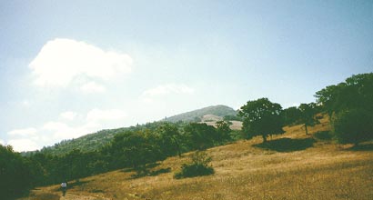
Annadel State Park, a wilderness at your doorstep, is just sixty miles north of San Francisco on the eastern edge of Santa Rosa. Hikers, horsemen, photographers, anglers, and joggers enjoy its 35 miles of trail, and there are nearly 5,000 acres of rolling hills, intermittent streams, meadows, and woodland, unmarred by modern intrusions. The park includes what many biologists consider the best example of northern oak woodlands in existence.
Temperatures are moderate: daytime high temperatures during the summer are in the 80s and 90s; wintertime highs are in the 50s. Rainfall averages about 30 inches a year, most of it during the winter and early spring. Snow is quite rare, and there is little fog.
The park offers many miles of trails for hiking, horseback riding, mountain biking, and trail riding. Lake Ilsanjo offers fishing. There is no camping in the park. It offers some of the most beautiful and bountiful displays of wildflowers from early March to late May.
Can I bring my dog to the park?
On certain dates, there are docent-led walks which offer visitors interpretive talks of the history and ecology of the park. The Schedule is updated monthly.
Two Indian groups- the Southern Pomo and the Southern Wappo- lived in the vicinity of the park. No permanent village sites have been found, but the park area was important to the Indians as a source of obsidian, which they used to make scrapers, knives, arrow points, and spearheads. Human use and settlement of this area changed dramatically after 1770 when the Spanish came to California. Cattle ranching and farming gradually replaced the age-old Indian pattern of hunting and gathering.
In 1837, Annadel was included in a Mexican land grant that covered some 19,000 acres. In the 1880s, sheep and cattle grazing gradually gave way to quarrying operations. There was great demand for cobblestone material when San Francisco and other west coast cities were being built and rebuilt after the 1906 earthquake. Cobblestone quarry operations were a major source of income to the Wymores and the Hutchinsons who were the principal land owners in this area around the turn of the century. In fact, the park takes its name from the granddaughter, Annie Hutchinson. It seem that this area was once known as "Annie's Dell"
Demand for cobblestone began to dwindle during the 1920s. Drivers of the new automobiles didn't care for the bumpy ride they got on cobblestone streets. Joe Coney began to buy property in this area during the 1930s. He used the land for agricultural purposes until the late 1960s, though he also mined for perlite, an obsidian product used as insulation. Annadel became a State Park in 1971.
Trails
Annadel's trail system travels through a wide range of plant communities. There are meadows, Douglas Fir forests, and chaparral areas, each of which are the result of environmental conditions that favor one type of plant over another. These various plant communities provide a variety of habitats - areas that suit certain kinds of animals or birds better than others. This diversity makes it possible to experience many different kinds of environments and to see a wide range of birds and other wildlife. Perhaps the best months to see the park's wildflowers are April and May, but there are some plants in bloom as early as January and as late as September.
Warren Richardson Trail commemorates Warren P. Richardson, a prominent cattle rancher and hop grower who organized the Sonoma County Trail Blazers and served as president of the California Horsemen's Association. The trail begins in a forest of Douglas-fir, bays, and redwoods. In March and April you may be able to spot the rare redwood orchid near where this trail intersects with Louis Trail. At about the 900-foot elevation level, the forest gives way to open meadows and mixed oak wood land where from March through July, you'll probably see a lot of plants with large, yellow blossoms rather like sunflowers. One look at the plant's leaves will make it clear how "mule ears" got its name. It will probably take you an hour or less to cover the two and one-half miles to Lake llsanjo, which was named for the property's former owners, Ilsa and Joe Coney. There are restrooms near the lake, and picnic tables scattered along the shoreline. You can make your hike a five-mile loop by returning along the steep Steve's S Trail.
Louis Trail. (Take Warren Richardson Trail to Louis Trail, then turn onto Steve's Trail, right on Burma Trail, and left on Live Oak Trail.) This route passes through four distinct plant communities in just a mile and one-half; Douglas-fir/bay forest; meadow with Oregon and black oaks; chaparral (chamise, manzanita, sticky monkey flower and, in April, May and June, golden fairy lanterns); and a short-grass meadow with large coast live oaks. The meadow is covered with goldfields in April and has a smattering of bitterroot at the southwest end from March through June.
Cobblestone Trail leads through an area that was extensively quarried in the early 1900s for cobblestone. At one time there was a gravity-powered, narrow-gauge tramway here that took cobblestone down to the main railroad line The stone was then shipped to San Francisco. More evidence of quarrying can be seen along Orchard, North Burma, Warren Richardson, Marsh, Two Quarry, and Lawndale Trails.
Spring Creek Trail is one of the most pleasant trails in the park on a hot summer day. None of the creeks within the park flow all year long, but even in the driest times, pools of water remain in the otherwise dry bed of Spring Creek, and there is enough water just below the surface that large water-loving alders and some redwoods grow alongside the stream bed. Chaparral surrounds the trailhead beside the dam that forms Lake llsanjo, but the trail quickly enters the forest. Look for checker lilies in February through May and for Chinese houses in March through July.
Marsh Trail climbs steadily from its beginning at the intersection of Canyon Trail. It then skirts the flank of Bennett Mountain. Some wonderful panoramic views of Lake llsanjo and the surrounding mountains can be seen. The trail runs through prime oak woodland, bunchgrass and Oregon oaks, and some cool islands of redwood.
South Burma Trail goes through a mixture of Douglas-firs and oaks as it leaves Warren Richardson Trail. As it climbs, you'll notice that the plants become more shrubby. Just before dropping down to Buick Meadow the trail passes through an acre or so that is blanketed with the delightfully pungent Sonoma sage, which blooms in May and June Look for scarlet fritillary from March through May.
Schultz Trail provides an opportunity to see how plant communities vary according to their exposure to the sun. Schultz Canyon runs east and west; its north side (which faces south) is mostly dry chaparral since it receives far more sunshine than the opposite, north-facing slope which is covered with Douglas-fir. Along the lower sections of this trail, if you look carefully, you can find redwood lilies in June and July. When it blooms, the beautiful trumpet-shaped flower is white; as it ages, burgundy spots appear until, near its end, the flower is entirely a purple/burgundy color. The upper stretches of the trail, which are drier, have oaks and manzanita. Look for the chaparral pea, a shrub or small tree that blooms from May through July.
Fishing
Lake Ilsanjo offers excellent fishing for black bass and bluegill. Black bass weighing nine pounds and more have been caught here. A purple plastic worm is a favored bait for the bass, while the bluegill favor garden worms, small crayfish, and grubs. If you are 16 years of age or older, you must have a California fishing license. Ledson Marsh dries up by late August or early September and so no fish are found there.
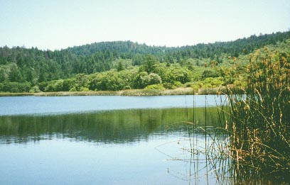
Lake Ilsanjo
Hiking Tips
Elevations in the park vary from 360 to around 1,880 feet, but most of the trails are moderate in grade. They are too rough, however, for ten-speed bicycles. Drinking water is available at the park office and the main parking lot at the east end of Channel Drive. There are a few rattle snakes in the park. Be alert for them as well as poison oak. Check all four sides of the 4"x4" posts that carry the metal trail signs to be sure you're taking the trail you intended. Hitching posts have been placed alongside the trails. Please note, however, that some of the trails are closed to horses and/or bicycles. Closures serve to prevent erosion and user conflicts. Please contact the park staff in advance of arrival if your horsemen's group is planning to visit the park. Annadel State Park is open daily from sunrise to sunset.
For wildflower lovers, Annadel Park offers a great variety of flowers from early Spring until early Summer, especially on a hike around Lake Ilsanjo.
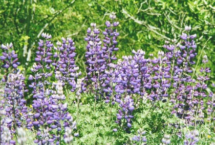
Lupine
For more information contact:
or
Annadel State Park
6201 Channel Drive
Santa Rosa, California, 95409
707/539-3911
or
Silverado District
20 East Spain Street
Sonoma, California, 95476
707/938-1519
Return to Parks Home Page
Proudly hosted by Sonoma.net