The Parks of the Coastal Region.
| Along more than thirty miles of rugged and scenic coastline of the
Sonoma coast are numerous parks where the visitor can camp, hike, observe a variety of sea
and bird life, and enjoy nature. The coast features stretches of wide, sandy beaches
and sections of rocky cliffs.
Visitors are warned of sudden "sneaker waves" when very large waves can sweep
up on the beach and carry off the unwary.
The coast bursts into color with a great variety of springtime flowers
starting in late February.
|

|
Parks are listed South to North.
Area
Map for Sonoma Coast State Beach
Doran Regional Park, located on the South side
of Bodega Bay off Highway 1, offers access to beaches, picnic areas, campgrounds
and a boat launch facility. Doran beach is probably the safest swimming beach
on the Sonoma coast.
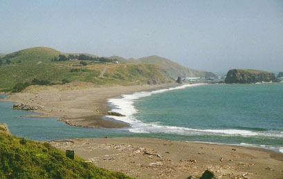
Sonoma Coast State Beach. Broad, shining beaches and secluded coves, rugged
headlands and natural arches, and a craggy coastline with tidal pools and reefs
characterize one of California's most scenic attractions - Sonoma Coast State Beach. The
beach, actually a series of beaches separated by rocky bluffs, extends 17 miles from
Bodega Head to Myer's Gulch, just south of Fort Ross in Sonoma County. It is accessible to
beachcombers, fishermen, sunbathers, and picnickers from more than a dozen points along
coast Highway 1. Generally north coast weather is a chilling combination of wind and fog.
Fortunately, during summer, the morning fog usually burns off by mid-day, making for
pleasant afternoons. However, even during summer, be prepared for wet, cold, and windy
north coast weather. This coast is not for swimming, and lifeguard service is not
provided. Sleeper waves, backwash, sudden drop-offs, rip currents and the cold water, make
even surf play or climbing on nearby rock outcroppings dangerous.
Camping is available at Wright's Beach.
Can I bring my dog to the park?
Bodega Head, located within Sonoma Coast State Beach, is an outcropping
which juts into the Pacific. California Gray Whales can be observed close to the coast as
they migrate South from early December through mid-February, and North from March until
early May. During the peak of the migratory season, Bodega Head is staffed every Saturday
and Sunday by volunteers of the "Stewards of Slavianka", who provide
interpretive information and help visitors spot the migrating whales.
Goat Rock, within Sonoma Coast State Park is located off Highway 1 at the mouth
of the Russian River. Dozens of mature harbor seals and seal pups can be observed on the
sandy shores of the Russian River where it meets the ocean. Although the seals may appear
tame, they frighten easily and, like all wild animals, can inflict serious bites. During
the March through June pupping season, people or dogs approaching too closely are serious
threats to the pregnant females and newborn pups. Pups are unable to swim, and when left
alone on land they are defenseless against predators.
This site includes four campgrounds and a picnic area.
Volunteers of the "Stewards of Slavianka" staff the area on weekends to provide
interpretive information and to keep the many visitors from getting too close to the shy
seals.
Goat Rock at Sonoma Coast State Beach and Mouth of Russian River
Area
map for Fort Ross, Stillwater Cove and Sea Ranch State Park
Fort Ross Historic State Park is located
on the coast, approximately 17 miles North of Jenner, off Highway 1. From 1812
to 1839, Fort Ross was the first major white settlement in the California coastal
region north of San Francisco. The fortification, gun towers and the buildings,
including a Russian Orthodox chapel have been restored and rebuilt. An excellent
small museum and a gift shop tell the story of the Russian settlers and the
native Americans who lived in this area.
Stillwater
Cove Regional Park is located just North of Fort Ross. The park
offers camping, ocean access and a trail through the Redwoods.
Public access to the coast is available from five parking lots which are
located off Highway 1, providing beach access, tide pooling, fishing, diving and
a sandy beach.
Salt Point State Park is located on the rugged northern California coastline about
ninety miles north of San Francisco on State Highway 1, nineteen miles north of Jenner.
The shoreline within the 6,000-acre park features rocky promontories such as Salt Point
which jut out into the Pacific Ocean. There are also a number of coves such as Gerstle
Cove and Fisk Mill Cove in the lee of points. The park includes one of the first
underwater parks in California. Fishing is permitted throughout the area with the
exception of Gerstle Cove Marine Reserve, within which marine life is completely
protected. The up-land portion of the park features both grassland and forest areas. The
most popular activities at Salt Point State Park include camping, picnicking, photography,
fishing, skin and SCUBA diving, as well as hiking and riding. Salt Point has a small
visitors center which is open from April to November on week-ends and holidays. There are
109 walk-in camp spots.
Tide Pool Walks are offered on Saturdays at 10 a.m. and the Junior
Ranger Program will be 1 pm to 2:30. A Junior Ranger
program is also offered on Sundays at 10am to 11:30.
These times can vary but all park activities are posted
each week at the kiosks, restrooms, visitor center and camp
host sites. There are activity sheets for the Junior Ranger programs
at Woodside and Gerstle kiosks. For more information contact Karen Broderick at
karen@mcn.org.]
Camping is available at 109 drive-in and 20 walk-in sites. These include flush toilets,
but no showers.
For diving conditions, call 707-847-3222.

Gerstle Cove at Salt Point State Park
Kruse Rhododendron State Reserve. This 317-acre state reserve is located
directly adjacent to Salt Point and features a beautiful second-growth redwood forest
mixed with Douglas firs, grand firs, tanoaks, and many rhododendrons. Each May the
green of the forest is punctuated by patches of pink as these rhododendrons burst into
bloom. The wealth of rhododendrons is a direct result of normal plant succession patterns
following a severe fire that once occurred here. Today, the regenerated forest is
gradually overwhelming the rhododendrons. There are five miles of hiking trails through
the quiet forest and a number of picturesque bridges over fern-filled canyons made by the
seasonal streams that abound in this region each winter.
Gualala
Point Regional Park is located at the North end of the Sea Ranch and
South of the town of Gualala. The park offers a campground, a visitor
center, a nice sandy beach, hiking trails and access to the Gualala River and
the Redwoods.
Return to Parks Home Page
Proudly hosted by Sonoma.net
To search coastal
real estate